

search the Original Green Blog
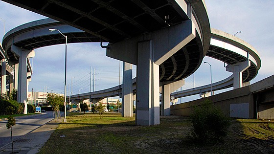
once a New Orleans neighborhood, now the dark underbelly of a Cheapway
The Cheapway is "the thoroughfare formerly known as the Freeway." The Freeway, of course, was originally designed to run freely in the countryside, carrying people quickly between cities and towns. But when it entered the city, the Freeway metastasized into its evil twin: the Cheapway.

nothing much grows next to a Cheapway except warehouses, seedy
bars, strip joints, and weeds
It is so named because it has likely destroyed over a trillion of dollars of real estate value around it in the US and drains municipal coffers across the country of billions in property taxes and sales tax revenues. As a matter of fact, most Cheapways destroy substantially more real estate value than the several-million-per-mile that it costs to construct them.
Cheapways were originally built to allow people to move to sprawling suburbs but work in the city. City-dwellers don't need them to get to their jobs downtown, of course, because they're living there already. So make no mistake: Cheapways weren't built for the city, but for the sprawling suburbs.
That might have seemed like a good idea in the late 1950s, but in less than a decade the Cheapway Consequence was becoming pretty obvious: pretty much everywhere they went in the city, decline and crime followed. This is so embedded in our culture that the underbelly of the Cheapway is second only to the parking deck as a setting for scary movie scenes.

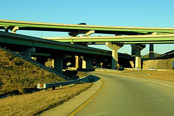
under the Cheapway
It is no coincidence that the arrival of the Cheapways heralded urban flight. Most American cities had emptied of the residents who could afford to leave by 1980. And then a really sad thing happened: Because they were then so scary, central cities no longer were perceived as good places to work. "Urban core" sounded almost as terrifying as "reactor core" for a generation to Americans. And so the jobs moved out to the suburbs, following their workers.
Now, we really must ask: if the suburban jobs are held mostly by suburban sprawl-dwellers, why do we need the Cheapways anymore? Haven't the cities suffered enough? Isn't it time to tear them down? John Norquist has been asking that question for years as champion of the Cheapway tear-down, beginning in Milwaukee when he was mayor there. He has now gone national with this cause as one of his roles as president of the Congress for the New Urbanism.

Cheapway crossing
It is far beyond the scope of this blog to show precisely how much value is lost; that sorely-needed study would best be handled by a university and could take years. But we can do a quick "smell test" that at least gives us a hint of the enormity of the problem. I chose Indianapolis for the test area because it's the city with Cheapways closest to Muncie, which was the site of the famous Middletown: A Study in Modern American Culture by Robert and Helen Lynd in 1929. I hope that Indianapolis is therefore pretty close to a US average condition.
After much searching, I found the wonderful City-data.com site, which has all sorts of great information you can drill down into. It's kind of like "GIS with a human face," meaning that you don't have to go to school to run it.
Particularly useful was their property tax assessments pages. They don't have every city, but they do have Indianapolis… or at least some streets in Indianapolis. East New York Street runs from the city center across I-65/70 and beyond.

the sample area, and properties sampled below
The following are some of the property values along East New York Street. I've shown them in red above; 302 is the leftmost property and 1417 is the rightmost property. Values are rounded to the nearest thousand dollars because my calculations are based on my measurements of the apparent site size from Google Earth, so I'm liable to be off by more than a thousand dollars because of not knowing the precise site size.
302: $2,646,000/.975 acres = $2,713,000/acre
359: $114,300/.034 acres = $3,319,000/acre
404: $50,100/.103 acres = $485,000/acre
434: $27,600/.063 acres = $437,000/acre
512: $66,900/.092 acres = $724,000/acre
602: $28,600/.241 acres = $119,000/acre
620: $30,000/.121 acres = $249,000/acre
719: $15,200/.201 acres = $76,000/acre
Interstate 65/70 occurs here, so for a distance of almost 400 feet, there is no real estate value because all of that land is in the right-of-way.
929: $35,500/.955 acres = $37,000/acre
1210: $7,500/.112 acres = $67,000/acre
1417: $10,400/.133 acres = $78,000/acre
Random samplings further eastward stabilize for quite some distance at $75,000 to $80,000 per acre. So how do we make sense of all this? Obviously, the land values drop precipitously beginning a few blocks from the interstate, then rise again to the level of the neighborhood on the other side. But had the interstate not been there, the value would likely have feathered more gently to the eastern neighborhood. The red curve below is the existing value The difference between the two curves below (the green area) is the value lost.

the sample area, with values above
I've assumed that the eastern neighborhood is held to its base value up to the outside of the Cheapway right-of-way. In reality, the downtown might extend value further. The total width of area affected is 4,728 feet - a swath nearly a mile wide along the Cheapway. The average property value lost over the affected area is $173,000 per acre. So in one mile of Cheapway, the total area is 4,728 feet x 5,280 feet = 573 acres. At $173,000 per acre, the Cheapway kills a staggering $99 million of real estate value per mile!
John Norquist told me that according to the 2004 Status of the Nation's Highways, Bridges, and Transit: Conditions and Performance report produced by the FHWA for Congress, there were approximately 46,747 route miles in the US Interstate System (circa 2002). About 70.8 percent (33,107 route miles) were in rural areas, 3.9 percent (1,808 route miles) were in small urban areas, and 25.3 percent (11,832 miles) were in urbanized areas. These figures are ten years old now, so the real number would now be larger, but if Indianapolis is average, then 11,832 miles losing $99 million of real estate value per mile totals $1.17 trillion!
Let that sink in for a minute... then consider that the US Department of Defense reportedly had direct expenses of $757.8 billion for the war in Iraq… less than 3/4 of the Cheapway Consequence. The entire 46,747-mile US Interstate system is estimated to have cost $425 billion in 2006 dollars, making it the largest public works project in human history, but those 11,832 urban miles alone have destroyed nearly three times that amount of real estate value!
And to think that a loss so massive has been hiding right under our noses in every American city served by a Cheapway! And Interstates make up only part of the total mileage of Cheapways, since there are many uncounted miles of urban expressways that aren't on the Interstate system.

before: San Francisco's hideous Embarcadero Expressway before the
World Series Earthquake took it down in 1989
source: geoimages.berkeley.edu
That is not, however, the end of the bleeding. According to the New York Times, the average state property tax rate in the US is 1.38%. So $1.17 trillion in lost property value costs the states over $16 billion per year in lost property tax. This number, so far as I can determine, does not include state school taxes. Many counties and cities levy property taxes as well. And a quick tour of the streets around most Cheapways reveals enough boarded-up windows that it's clear that billions in sales tax revenues are being lost as well. There is no clear way to estimate these losses because so many taxing authorities are involved, but based on the $16 billion lost just on state property taxes, the total is obviously well into the dozens of billions per year.

after: the fabulous Embarcadero boulevard that replaced it has
created untold millions of dollars in property value and tax revenue
I normally try to draw a persuasive conclusion about the contents of a post, but the numbers above speak so loudly for themselves that there's not much else to say. Let's just say that the Cheapway Consequence is simply a burden too great to bear. The time has come to tear the Cheapways down and replace them with great urban boulevards that create value instead.
~Steve Mouzon
Note: This post is part of an extended BlogOff on Return on Investment (RoI) of municipal spending. These are the posts in the BlogOff so far… please join us!
2/20/12 - The Speed Burden, Steve Mouzon
1/27/12 - On the Street: The DNA of place and the ROI of movement, Hazel Borys
Another Note: This is part of an occasional series on the costs of sprawl I started in March 2011 with Costs of Sprawl - Part 1, and continued with The Speed Burden noted above. Lots more to come… hopefully more quickly next time.
